Historic Landscape
Characterisation
The Gwent Levels
21 Maerdy
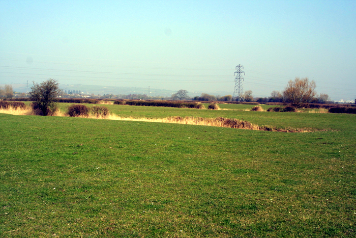
21 Maerdy character area: "regular landscape"
of medieval/post-medieval date in low-lying back-fen.
(Photo: GGAT Gwent Levels 099)
Click here for a character
area map
The long narrow fields, though superficially similar to the Roman landscape of Peterstone, are of different dimensions. This landscape was created through the enclosure of this block of open moor sometime in the medieval/post-medieval period.
Unfortunately, the creation of this landscape is not documented.
Key historic landscape characteristics
Former open moor: regular unified fieldscape of long narrow fields
(ie single operation), drainage features mainly reens, dispersed settlement
(includes Maerdy - medieval Reeve's house)
This area is intermediate in elevation between the higher coastal lands to the south, and the lowest-lying back-fen to the north. The distinct and well defined block of landscape is bounded by Drenewydd and Percoed Reen to the north (area 20), Broadway Reen (area 17) to the west, and the former fen-banks of St. Brides to the south and east (areas 15 and 16).
This large area can be divided into four blocks of long narrow fields (divided by Horsecroft and Summerway Reens, and Hawse Lane). They represent large areas of open land, enclosed and drained as a single operation. There are two farms; Maerdy was probably founded when the area east of Hawse Lane was enclosed, while Hawse Farm, which lies beside one of St. Brides' fen-banks, may have been responsible for the enclosure of the whole block of landscape to the north. The place-name Maerdy (medieval Reeve's house) is interesting, the location of Maerdy farm is indicative of the formal control of grazing on the formerly open back-fen Moor during the medieval period.
These long narrow fields are characteristic of Wentlooge. The landscape here was created through the enclosure and drainage of a large block of open moor, beyond the old enclosed lands of St. Brides. Two discrete landscapes can be identified, associated with Maerdy and Hawse Farms.
This is a very open landscape, and the reed-filled ditches give a strong wetland feel, typical of the lower-lying back-fen areas.
Overall, the integrity and coherence of this area are extremely high.
The two landscapes represent discrete examples of landscape creation.
The completeness of these landscapes makes them of great importance. Walking
north down Hawse Lane gives the impression of the back-fen being lower
than the coastal areas to the south. The area has suffered from agricultural
improvement, but remains remote from visually intrusive development; there
are fine views of the relatively unspoilt uplands.